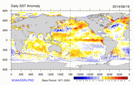
(Global Sea Surface Temperature Anomaly on June 19, 2014. Note the blossom of red and orange off the western coast of South and Central America. That’s very hot water in the Eastern Pacific. Image source: NOAA/ESRL)
The global weather altering event that is El Nino again took a step forward this week as temperatures in the Equatorial Pacific continued to rise, today hitting values of +0.78 C above the 1979 to 2000 average. An impressive climb adding to already warm readings which, since late May, have ranged between +0.6 and +0.68 C. It’s a strong rise that continues to show progress toward El Nino, increasing ocean-to-atmosphere heat transfer, and raising the likelihood that 2014 may break the all-time global high temperature records last set in 2010.
NASA Shows May Heat Record Shattered, Japan Meteorological Agency Records Hottest Spring
Already, even as the monster that is El Nino combined with human warming still struggled to emerge from Pacific waters, spring of 2014 set new global atmospheric heat records. According to NASA, this May was the hottest in the global measure, meanwhile, the Japanese Meteorological Agency marked the March-April period as the hottest spring in all of the past 130 years (NASA showed the same period was second hottest). Rising Pacific Ocean surface temperatures by themselves were enough, when combined with raging human greenhouse gas heat forcing, to nudge atmospheric temperatures into a new record range. But the emergence of full-blown El Nino will likely push current record readings even higher.
Wedge of Very Hot Water Stretching Out From South America
Now by mid-to-late June, a hot wedge of very warm water is flooding out from South America covering a large swath of ocean from the Ecuador coast and stretching all the way into the Central Pacific. Temperatures in this broad zone range from an impressively hot +1 C to an extraordinary +3 to +4 C in hot pools just off shore. This makes the Eastern Pacific a zone of hot water that now rivals and likely exceeds the extreme temperature departures in regions of anomalous warm water off the Pacific Northwest Coast and in the North Atlantic. A well of heat energy that is likely already extending an influence into global weather patterns, as seen in the continued delay and disruption of the Indian Monsoon over the past week.
(Very hot pool of water off Ecuador showing sea surface temperature anomalies in the extraordinarily hot +2.25 to +4 C range with smaller pools of +4 C and hotter water visible in this NOAA/NWS graphic.)
During March, sub-sea temperature anomalies spiked to +5 to +6 C above average in the hottest zones. So it appears, now, that some of these sub-sea anomalies are hitting the surface, clogging up the Pacific’s ability to soak up atmospheric heat and allowing that heat to accumulate.
Trades Picked Up, Then Stalled Again
Last week, atmospheric feedback promoting El Nino had appeared to weaken. The east-to-west trade winds had picked up and few countervailing west winds running from Asia toward the Americas were observed. But by this week, the trades had again faded with west winds seen north of the Solomons, east of the Phillippines, and along a broad zone in the Eastern Pacific. A re-emergence of an atmospheric feedback necessary for El Nino’s continued development.
Overall, ongoing warming in the Eastern Pacific along with a renewed weakening of the trades shows devolopment toward the predicted El Nino and an ongoing enhanced likelihood that past global high temperature records will continue to fall during 2014.
Links:
NASA Shows Global High Temperature Record Shattered
Climate Reanalyzer Daily Summary
Advance of the Southwest Monsoon 2014
Monster El Nino Emerging From the Depths
Source: Robert Scribbler


